First set of pictures captured, confirms ISRO
Chennai, Mar 12:
The Indian Space Research Organisation (ISRO) on Monday announced that INSAT-3DS, the meteorological satellite, has initiated earth imaging operations.
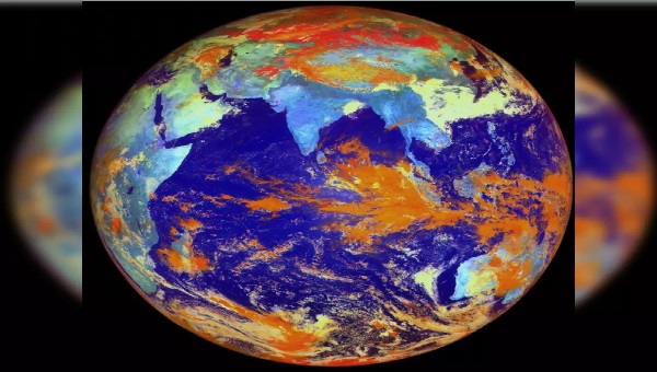
The first set of images by the meteorological payloads (6-channel Imager and 19-channel Sounder) was captured on March 7.
In a post on X, ISRO said “INSAT-3DS Mission: First glimpse of the beauty and complexity of earth through modern Imager and Sounder payloads onboard INSAT-3DS.
“This data serves as crucial input for Indian scientists for meteorological studies, weather forecasts, and understanding atmospheric dynamics”, it said sharing a number of pictures captured by the satellite.
The satellite was launched on February 17 from the spaceport of Sriharikota. India’s heavy rocket GeoSynchronous Launch Vehicle GSLV-F14 successfully injected ther 2,274 kg INSAT-3DS, a meteorological and disaster warning satellite into the desired orbit.
After completing orbit-raising operations, the satellite reached the designated geostationary slot for the In Orbit Testing (IOT) on February 28.
IOT of the Satellite Communications was conducted between February 29 and March 3, 2024.
As part of Meteorological Payload IOT, the first session of imaging for Imager and Sounder payloads was carried out on March 7, 2024.
The payload parameters are found to be nominal, complying with payload specifications.
“Thus, all the payloads of INSAT-3DS have been tested to perform nominally”, ISRO said. The Space Agency said Imager and Sounder payloads onboard 3DS are similar to the payloads flown on 3D and 3DR.
Significant improvements have been achieved in radiometric accuracy, black body calibration, thermal management, and imaging throughput, among others.
The payloads are designed and developed at the Space Applications Centre (SAC), Ahmedabad.
The first images are processed and released at the Master Control Facility, Hassan.
The 6-channel imager equipment captures images of the Earth’s surface and atmosphere across multiple spectral channels or wavelengths. The use of multiple channels allows for gathering information about various atmospheric and surface phenomena, such as clouds, aerosols, land surface temperature, vegetation health, and water vapour distribution. The imager could be configured to capture specific features of interest.
The 19-channel sounder captures radiation emitted by the Earth’s atmosphere through channels carefully chosen to capture radiation emitted by different atmospheric constituents and properties like water vapour, ozone, carbon dioxide, and other gases, while others may be designed to measure temperature variations in different layers of the atmosphere.
These Payloads generate over 40 geophysical data products such as Sea Surface Temperature, Rainfall (precipitation) Products, Land Surface Temperature, Fog Intensity, Outgoing Longwave Radiation, Atmospheric Motion Vectors, High-Resolution Winds, Upper Tropospheric Humidity, Cloud Properties, Smoke, Fire, Mean Surface Pressure, Temperature Profiles, Water Vapor Profiles, Surface Skin Temperature, Total Ozone, etc., for the user community.
The data collected derive information about the vertical structure of the atmosphere, crucial for weather forecasting, climate monitoring, and understanding atmospheric processes.
The lINSAT-3DS represents a significant milestone in India’s space journey, underscoring ISRO’s commitment to harnessing space technology for societal benefits.
With its advanced capabilities and collaborative development approach, INSAT-3DS will bolster India’s capabilities in meteorology, disaster management, and beyond, reaffirming the nation’s prowess in space exploration and innovation.
The primary objectives of the mission are to monitor Earth’s surface, carry out Oceanic observations and its environment in various spectral channels of meteorological importance; to provide the vertical profile of various meteorological parameters of the Atmosphere; to provide the Data Collection and Data Dissemination capabilities from the Data Collection Platforms (DCPs) and to provide Satellite Aided Search and Rescue services.